


DJI Dock 3 + DJI Matrice 4D – Autonomous Drone System for Mapping and Inspection
The DJI Dock 3 + DJI Matrice 4D set is a complete, autonomous system for carrying out drone missions without an operator on site. The solution is designed for mapping, 3D photogrammetry, infrastructure inspection, and BVLOS operations.
The combination of the DJI Dock 3 station and the DJI Matrice 4D drone enables automatic take-off, landing, charging, and mission execution — 24 hours a day, 7 days a week.
54 min
Max. M4D flight time
2.8 km²
Coverage in one flight
1800 m
Laser rangefinder range
IP55 / IP56
Drone / station protection
- ✔ 24/7 autonomous missions (DJI FlightHub 2)
- ✔ drone takes off in approx. 10 seconds
- ✔ mapping without GCPs — 4/3" CMOS camera with mechanical shutter
- ✔ 3D photogrammetry — 5-directional oblique photos, 3-directional orthophotos
- ✔ RTK system — centimeter-level precision
- ✔ 1800 m laser rangefinder
- ✔ resistance: IP55 (drone) / IP56 (station)
- ✔ ready-to-deploy system
Dock + Matrice 4D System – Automatic Mapping and Inspections
The set combines a docking station and a drone into one integrated operating system. The Dock is responsible for logistics and automation, and the Matrice 4D for collecting spatial data and mission execution. An ideal solution for cyclical measurements, investment documentation, and infrastructure monitoring without the presence of an operator on site.
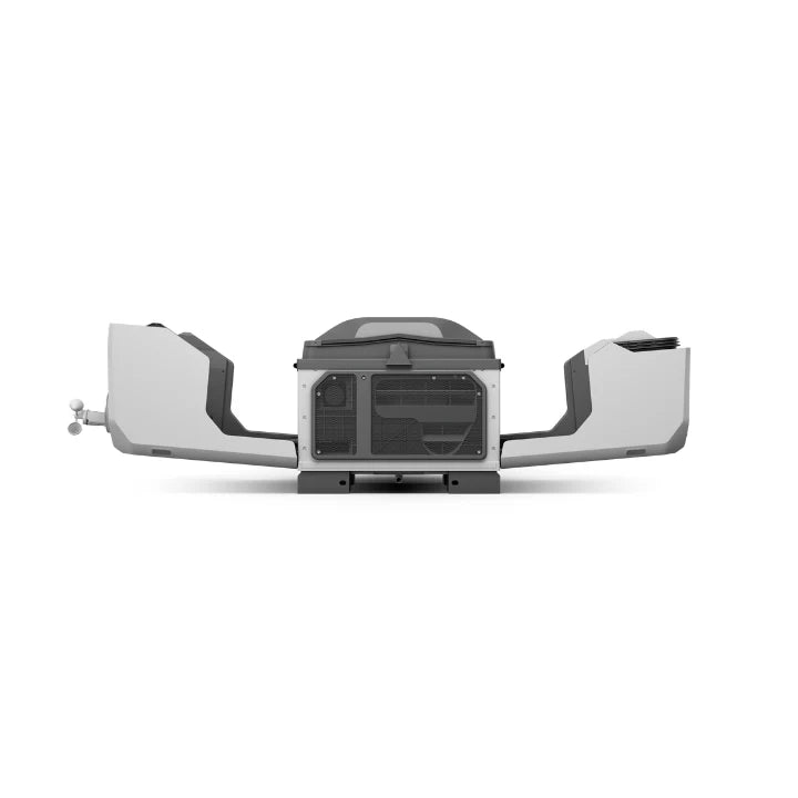
DJI Dock 3 – Autonomous Operations Base
DJI Dock 3 is a new generation station enabling full automation of operations:
- automatic drone take-off and landing
- charging 15%→95% in approx. 27 minutes (Ready-to-Fly mode)
- built-in RTK system — accuracy H: 1 cm + 1 ppm
- 9 antennas, Ethernet 10/100/1000 Mbps + 4G (with DJI Cellular Dongle 2)
- environmental sensors: wind, rain, temperature, humidity, flooding
- external camera 1920×1080, FOV 151°
- Class II lightning protection — 20 kA
- operation: -30°C to +50°C, IP56, up to 12 m/s wind
- vehicle mounting (as the first DJI station)
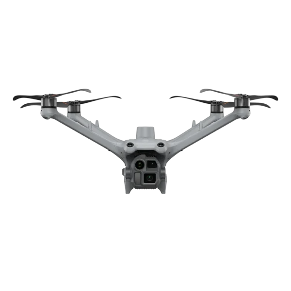
DJI Matrice 4D – Drone for Mapping and Photogrammetry
DJI Matrice 4D is a professional drone designed for collecting spatial data and creating 3D models:
- Wide-angle camera — 4/3" CMOS, 20 MP, f/2.8–f/11, mechanical shutter, 0.5 s interval, JPEG + RAW support, mapping without GCPs
- Medium telephoto camera — 1/1.3" CMOS, 48 MP, f/2.8, 70 mm
- Telephoto camera — 1/1.5" CMOS, 48 MP, f/2.8, 168 mm, 112x hybrid zoom
- Laser rangefinder — 1800 m range (1 Hz), accuracy ±(0.2 + 0.0015×D) m
Precision and Efficiency in the Field
- flight time up to 54 minutes (forward flight) / 47 min (hover)
- RTK — centimeter-level accuracy, mapping without GCPs
- IP55 — protection against dust and water
- operation in temperatures from -30°C to +50°C
- wind resistance up to 12 m/s
- 12 mm cable detection at 15 m/s (optional module)
- DJI O4+ Enterprise transmission: FCC 25 km / CE 12 km
Battery — Stable Operation in the Field
The set includes the DJI Matrice 4D/4TD Series battery with self-heating function for operation in sub-zero temperatures. Charging via Dock 3 in approx. 27 minutes (RTF) — minimal downtime between missions.
Connectivity and Mission Management
- DJI O4+ Enterprise — FCC 25 km / CE 12 km
- management via DJI FlightHub 2 (EU servers, ISO 27001)
- Smart 3D Capture — automatic routes for 3D models of complex buildings
- automatic change detection (vehicles, anomalies)
- real-time monitoring and alerts
- manual control via DJI RC Plus 2 Enterprise
System Application
- mapping and 3D photogrammetry (geodesy, construction, mining)
- investment monitoring and progress tracking
- infrastructure inspections (power lines, bridges)
- resource inventory and terrain analysis
- BVLOS operations and 24/7 autonomous missions
Set Contents
| Docking station | DJI Dock 3 |
|---|---|
| Drone | DJI Matrice 4D |
| Controller | DJI RC Plus 2 Enterprise |
| Battery | 1× DJI Matrice 4D Series Battery |
| Charging hub | Yes |
| Transport case | Yes |