


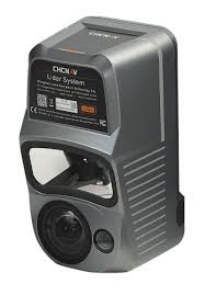
CHCNAV AlphaAir 10 (AA10) – LiDAR Drone Scanner with 45 MP RGB Camera
The CHCNAV AlphaAir 10 is a compact UAV LiDAR system combining a laser scanner (up to 500,000 pts/s, 800 m range, 8 echo returns), a 45 MP RGB camera, and a 500 Hz IMU with GNSS RTK. It offers 5 mm precision, 2-5 cm absolute accuracy, and IP64 rating. Designed for surveying, 3D mapping, and vegetation analysis.
500,000 pts/s
Point Cloud Density
800 m
Range (high reflectivity)
5 mm
Measurement Precision
8
Echo Returns
Technical Specifications
| Point cloud density | Up to 500,000 pts/s |
|---|---|
| Range | Up to 800 m (high reflectivity) / up to 400 m (standard conditions) |
| Minimum range | 10 m |
| Accuracy | 10–15 mm (1σ) |
| Precision | 5 mm (1σ) |
| Absolute accuracy | 2–5 cm (after processing) |
| Number of echo returns | Up to 8 |
| FOV | 75° |
| Scanning speed | 50–250 scans/s |
| RGB camera | 45 MP |
| IMU | 500 Hz, orientation accuracy up to 0.006° |
| GNSS | GPS, GLONASS, BeiDou, Galileo Accuracy: 0.010 m (H) / 0.020 m (V) |
| Power consumption | 40 W |
| Voltage | DC 24 V (13–27 V) |
| Protection class | IP64 |
| Operating temperature | -20°C to +50°C |
Applications
- Surveying and cartography (DEM, DSM, orthophotos)
- 3D mapping and photogrammetry
- Forestry – biomass and tree crown structure analysis
- Infrastructure and energy inspections
- GIS projects and environmental analysis
FAQ
What is the real accuracy of the AA10?
5 mm precision (1σ) – repeatability of consecutive measurements. Absolute accuracy of 2–5 cm after full processing with RTK.
Does the AA10 work in dense forests?
Yes – 8 echo returns allow collecting ground points under dense tree canopy for DTM creation and biomass analysis.
Which UAV platforms is the AA10 compatible with?
The system is compatible with popular enterprise-class UAV platforms. Power supply DC 24 V (13–27 V), power consumption 40 W. For integration details, please contact us.