


Product description
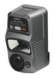
The CHCNAV AlphaAir 10 (AA10) is an advanced LiDAR + RGB system designed for professional aerial mapping and UAV photogrammetry. Integrates high high-precision LiDAR scanner, GNSS module, IMU and full-frame camera 45 MP, which allows for detailed point clouds and ortho images for creating extremely accurate 3D models. Lightweight, compact design and easy assembly enable quick integration with various drone platforms, which makes the AA10 is an ideal tool for surveying, cartography, engineering and inspection infrastructure. :contentReference[oaicite:0]{index=0}
Technical specifications
General
| System type | Airborne LiDAR + RGB System |
|---|---|
| Libra | 1.55 kg |
| Dimensions | 210 × 112 × 131 mm |
| Degree of protection | IP64 |
| Operating temperature | -20° to +50°C |
| Storage temperature | -20° to +60°C |
LiDAR
| Measurement range | Up to 800 m |
|---|---|
| Scanning speed | 500,000 points/sec |
| Fields of view | 75° |
| Number of returns | Up to 8 |
| Absolute accuracy | 2–5 cm RMS (H/V) |
Positioning and IMU
| GNSS | Full GNSS (GPS, GLONASS, BeiDou, Galileo) |
|---|---|
| IMU | 500 Hz |
| Position accuracy | ~1–2 cm after post-processing |
Camera
| Image resolution | 45 MP |
|---|---|
| Focal length | 21 mm |
| Sensor | Full-frame orthophotographic |
Data and memory
| Memory capacity | 512GB ×2 |
|---|---|
| Write speed | ~80 Mb/s |
Applications
| Typical applications | Topographic mapping, 3D models, DEM/DSM, infrastructure inspections |
|---|